Investigators from the NASA Ames Research Center (ARC) in Moffett Field, California, this year participated in an expedition to study the Surprise Valley Fault, a fault line located in northeastern California, alongside the Warner Mountain Range.
Usually, experts use 4WD, all-terrain vehicles, and plain old hiking, to perform ground surveys of the area, but these techniques do not yield as much data as investigators need to gain an accurate understanding of what goes on in the underground.
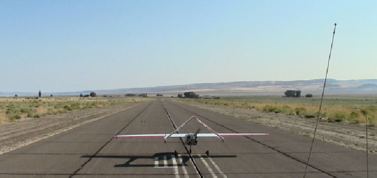
This is why experts wanted to use an unmanned aerial vehicle (UAV) for this year's expedition. ARC was quick to respond to this need with its Sensor Integrated Environmental Remote Research Aircraft (SIERRA). The airplane is managed by, and operated from, the Ames Research Center.
This is why the US Geological Survey (USGS) began conducting research in the area years ago. Experts here needed access to low-flying aircraft capable of surveying the region, and of covering significant distances. SIERRA boasts a flight range of 965 kilometers (600 miles).
The aircraft can carry payloads weighing as much as 45 kilograms (100 pounds), which is a lot, considering its ultralight construction. One of the things that made it especially useful for this mission was that it's very capable of flying at low altitudes.
“This mission highlights an important science niche for the small to medium class of unmanned aircraft. These aircraft can collect data at slow speeds at very low altitudes over the surface in remote locations without risking life, or high-value aircraft,” SIERRA project manager, Matt Fladeland, says.
In addition to experts from ARC and the USGS, the research team also included scientists from the Carnegie Mellon University, in Pennsylvania, and the Central Washington University, in Washington.
The main payloads on SIERRA are a cesium magnetometer and a fluxgate magnetometer, both of which are used to analyze magnetic circulation over the target area. This is important because underground movements are bound to cause detectable distortions.
A comparison of new magnetic data to older topographic data will reveal any type of underground motions that may have occurred since last year. Combining these data with GPS information will increase the amount of scientific return from the expedition even further.
Via: NASA Deploys UAV to Study Fault Line in California
Tidak ada komentar:
Posting Komentar